Today’s Elevation on Lake Pend Oreille
Natural History
Lake Pend Oreille has a fascinating geologic history. Carved out by glaciers moving south from Canada some 12,000 to 17,000 years ago, and shaped by hundreds of gargantuan ice age floods, it is Idaho’s largest and deepest lake at 1172 feet. It’s the 5th deepest in the United States and 13th in the world! Because of its great depth, it is used by the Navy to test new submarine technology.
Lake Pend Oreille is home to an abundance of wildlife and has a great fishery, including the world record kamloops trout, a type of rainbow trout, caught in 1937 and weighing 37 pounds. In addition, a world record bull trout was caught in Lake Pend Oreille in 1949 weighing 32 pounds. Bald eagles and osprey are a common site. Bears, moose, deer, wolves, mountain goats and more can be seen along the shoreline of the more remote areas.
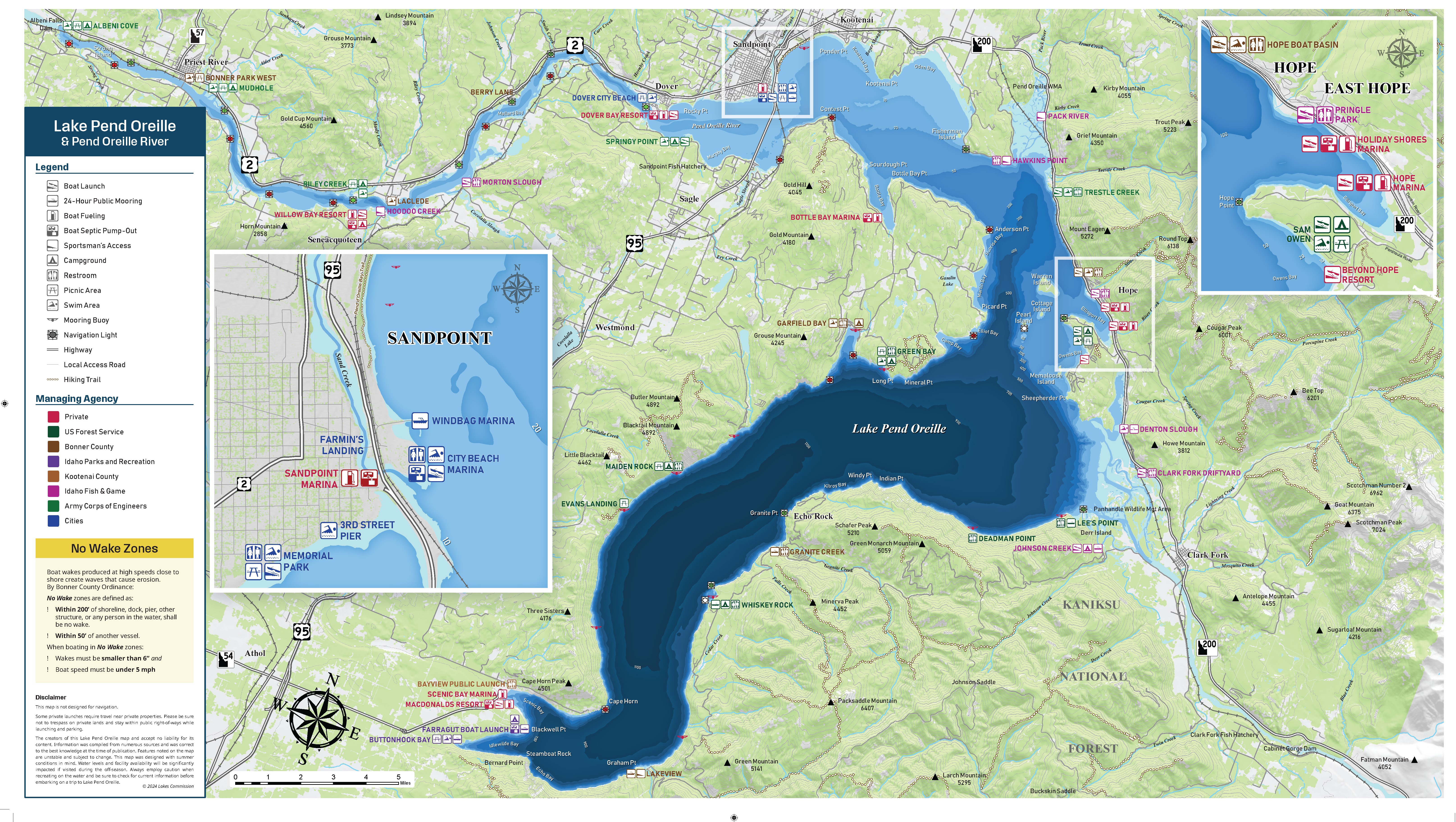
With 111 miles of shoreline, and 43 miles long, Lake Pend Oreille provides many recreational opportunities. Surrounded by 3 major mountain ranges, the Selkirks, Cabinets, and the Bitterroots, its natural beauty and abundant resources make it a very special place to experience and respect.
ALBENI falls dam & lake levels
Today’s Elevation on Lake Pend Oreille
Historic Elevations on Lake Pend Oreille – in the blue box you will see Begin and End Dates, enter the dates you are interested in.
Historic Flooding on Lake Pend Oreille
2,075.88 ft on 06/01/1894
2,071.62 ft on 06/09/1948
2,068.76 ft on 06/20/1933
2,067.11 ft on 06/10/1950
2,065.70 ft on 06/12/1972
2,065.47 ft on 06/23/1974
2,065.74 ft on 06/05/1997
2,064.29 ft on 06/17/2011
2064.20 ft on 06/29/2018
The Lakes Commission was formed, in part, to advise the State of Idaho on lake level management on Lake Pend Oreille and the Pend Oreille River. Albeni Falls Dam (AFD), located between Priest River and Oldtown, Idaho, is a federally operated project managed by the U.S. Army Corps of Engineers (USACE). The USACE work in partnership with Bonneville Power Administration(BPA), who markets power generated at AFD and throughout the Federal Columbia River Power System.
Although Lake Pend Oreille is a natural lake, the top 11.5 feet of Lake Pend Oreille have been used for storage since the construction of Albeni Falls Dam in 1955. This stored water can be manipulated according to Congressional agreements and conditions put in place prior to construction of the dam. These congressional directives were established in order to benefit and support our local communities Albeni Falls Dam was built with multiple and equal purposes: power generation, recreation, navigation, fish and wildlife, and flood control. The flows from the Pend Oreille Basin contribute substantially to the entire Columbia River Basin and provide economic and ecological benefits both upstream and downstream. The State of Idaho, who holds the water right for Lake Pend Oreille and the Pend Oreille River (upstream of the dam), relies on the original congressional agreements for dam operations and lake levels, knowing that there are numerous pressures on the waters of Lake Pend Oreille and that balancing all the desired uses is complex and challenging.
The normal pool elevation (late spring through fall) is to be held between 2062′ to 2062.5′ above sea level for recreation, fish and wildlife habitat, navigation, and scenic beauty. When, and for how long normal pool elevation is maintained (stabilized) has been an ongoing conflict. But in the congressional agreement, it is to be maintained for 6 months.
April through May is when we see what mother nature has in store for us in the form of spring runoff and snow melt. The low (maximum) winter drawdown (2051), that has been taking place for the past 10 plus years, has no impact on the dams ability to control flooding. In fact, the lake can, in practice, be at normal pool all winter, it just cannot be higher than 2056′ elevation on April 1 (spring runoff coming). The two main factors currently preventing a higher winter pool are kokanee incubation timing and Flexible Winter Power Operations (FWPO). More on each of those below.
If it is a flood year, the lake will, more often than not, rise above normal pool. Flood stage on Lake Pend Oreille is 2064′. This is a rare occasion happening approx. every 10 years. When Lake Pend Oreille is flooding, Albeni Falls Dam doesn’t have control anymore and they open all the spillway gates. Once flood risk is over, they start closing the gates and stabilizing the lake to normal pool of 2062′-2062.5′. Albeni Falls Dam only decreased flooding by 1 foot vs pre dam flooding, according to the USACE Water Control Manual. This means that when its a flood year, we are going to flood one way or another, but likely won’t go above 2065. 5. There is evidence that flood risk could be further reduced upstream at Hungry Horse Dam by releasing less water in the spring. Instead, slowly releasing the cold water from Hungry Horse’s bottom fed dam during the summer/fall when native fish species need it most. Hungry Horse Dam is managed by the US Bureau of Reclamation.
If we are NOT in a flood year and all hydrologic reports show there will be a low or normal spring runoff, Albeni Falls Dam has control of the lake levels via the gates and can bring it up to normal pool elevation without risk to flooding. Normal pool must be reached by July 4th, but can be stabilized anytime after May 1st and flood risk has passed. The Water Control Manual Table below shows they can start refill May 1st and be stabilized at normal pool of 2062.5 anytime between May 1st and May 31st. For the past several years, the normal pool was stabilized from mid-June to September 18th.
In the Fall, the USACE can begin drafting on September 1 with a maximum drawdown to 2060′ by September 30. However, after public pressure, there is currently an agreement for a later September drawdown of Sept 18th or the 3rd Sunday in Sept, whichever is later. The lake won’t begin its full drawdown until Oct 1st and will be at its winter elevation by Nov 15th. The winter pool needs to be reached by the second week in November so shoreline kokanee spawners are not left high and dry.
The winter lake level has been its lowest (2051′) for the past 11 years because of an agreement with Bonneville Power Administration for Flexible Winter Pool Operations. But in the past, it was held half way at 2056′ periodically. According to the Water Control Manual Table below, this is still allowed. Since the winter of 2011-2012, FWPO allows the lake level to rise up to 5 feet in the winter, allowing for increased power generation. This is referred to as Flexible Winter Pool Operations(FWPO). The Lakes Commission would like to see changes to this operation, in order to allow for a higher winter lake level, improving public access to docks and launches, creating more fish and wildlife habitat, stability to the shoreline and improving property values.